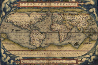
Cartography is the efficient communication of spatial information; which at the center of it has a map-making process.
The history of cartography dates backs thousands of years ago in human history. Maps have been one of the most important human inventions for many years, allowing humans to explain and navigate their way through the world.
 |
| Ancient Cartography Maps |
But the maps now or cartography field is getting smarter and dynamic in nature showing us the world from a different perspective under different parameters. Cartography like many other fields has undergone rapid changes in the last decade due to the rapid advancement of Information technology. Cartography or Mapping can be used in interdisciplinary decision-making and raising awareness on global agendas and for a sustainable world too. The whole cartographic process is now concerned with data collection, data manipulation, image processing, and visualization.
The representations may appear in printed form or as a digital form which is dynamic in nature. Computer-assisted cartography has supplemented new cartographic techniques as an augmentation of new skills, which makes cartography dynamic with new methods for visualization and communication or presentation of spatial information. Computer-Assisted Cartography, Web Cartography, GIS are emerging as a modern deviant of the cartographic field.


0 Comments